If any trekking destination in Nepal pushes the boundaries in terms of adventure and obstacles, it’s the Everest Base Camp Cho La Pass Gokyo Trek. It forces hikers to discover many hidden gems, enjoy magnificent views, and take a perfect photo of Mt. Everest.
The trek is significantly more tough than others, but the Nepal Eco Adventure will take you on a fascinating experience. A trekking guide and porter will accompany you throughout the route, making the experience a little easier and better straight from Lukla.
NOTE: This is a 15-day trek (KTM to KTM) that does not include the days of arrival, sightseeing, and departure. Additionally, the hotel and sightseeing trip charges are not included in this 15-day itinerary. Please see our 18-day EBC Chola Pass Gokyo Trek for $1,800 per person if you want to include a sightseeing tour and hotel stay.
The Everest Base Camp Cho La Pass and Gokyo are located in Khumbu village, which is located in north-eastern Nepal. While Everest Base Camp is located at the base of Mt. Everest, Gokyo Valley is located at 5,357 meters on the base of Gokyo Ri..
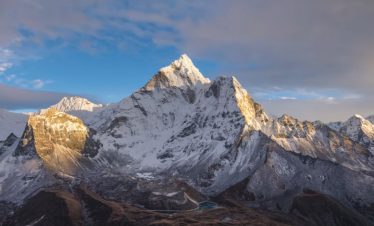
The base camp is located on the main EBC trail, whereas Gokyo passes through the Cho La Pass, one of the most difficult sections of the trip. It is, however, rather magnificent, with breathtaking scenery of gleaming mountains such as Ama Dablam, Mt. Everest, Nuptse, and Gokyo Ri.
Gokyo is a small town located on the eastern bank of Dudh Pokhari, the third Gokyo Lake. All of the structures and houses in the valley are utilized to shelter trekkers. Gokyo has six major lakes, including Thonak, which is fed by melting glaciers.
Overview
Everest Base Camp with Gokyo Trek via Cho La Pass is famous for its unrivaled beauty, geological wonders, local grandeur, and breathtaking views.. The climb is magnificent, with breathtaking views of gleaming mountains such as Ama Dablam, Mt. Everest Nuptse, and Gokyo Ri.
Its historical landmarks, like as medieval monasteries, Mani walls, and prayer wheels, provide insight into the Himalayan people’s culture. This allows them to better comprehend the customs and traditions of the Everest region’s residents, who are largely Sherpa and Tibetan.
People from various castes have migrated to the region throughout the years, thus you may come across Brahmin, Chhetri, Sherpa, and Rai. Tengboche monastery is one of the most important tourist attractions in Khumbu and is visited by the majority of trekkers.
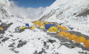
At 5,364 meters height, Everest Base Camp is located in the south of Khumbu. It’s around 144 kilometers from Kathmandu, with the actual trek beginning in Lukla. The trail that leads from this little Sherpa settlement passes past various villages, including Namche Bazaar and Dingboche.
The trail traverses suspension bridges over the Dudh Koshi River and climbs a high slope several times. It follows a terrace farm and crosses steep routes with sharp rocks to reach Everest Base Camp.
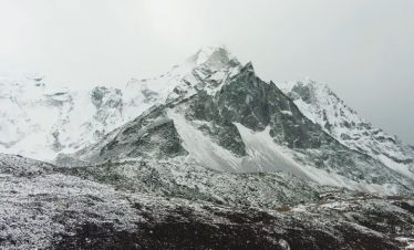
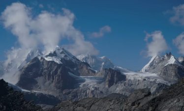
With terminal moraines and ice sheets, the trek becomes extremely arduous from the base camp. The route to Gokyo passes across Cho La Pass (5,420 meters) and crosses the Ngozumpa glacier to the east.. This mountain pass connects the villages of Thangnak and Dzonglha, both of which are surrounded by mountains and tall hills.
The trail then ascends from the jagged and rocky landscape, crossing Thangnak. The hike from the town to the first Gokyo Lake takes around 2-3 hours, and continuing on will take you to the second Gokyo Lake. The third Gokyo Lake is located near the Gokyo Valley and offers a breathtaking view of Gokyo Ri.
The fourth and fifth Gokyo Lakes can be reached by walking across hard terrain with loose rocks and boulders beyond Gokyo towns. Once reaching the last lake, you’ll be rewarded with a beautiful vista of quiet lakes, various landscapes, sheer glaciers, and breathtaking mountains..
Highlights
- Very scenic flight to Lukla with views of soft rolling hills, lovely villages, and lush meadows.
- Stunning views of the Khumbu Icefall, Mt. Everest, and Ama Dablam
- Offering prayers at Tengboche Monastery
- In Sagarmatha National Park, there is a chance to see wild animals and birds.
- Visiting the neighboring vistas, cliffs, and steep-sided hills.
- Explore the secret Gokyo Valley and its surrounding glacier lakes and moraines.
- Seeing historic Chortens and Gompas, as well as colorful Mani walls and prayer wheels.
- Close-up of snow-capped mountains, icefalls, and rocky hills.
Itinerary
Overnight at at the Lodge
We'll depart from Kathmandu to Lukla, which takes around 45 minutes to an hour. Enjoy the spectacular views of rolling landscapes, wide meadows, rural farms, and clifftops until then.
We'll arrive at the charming town of Lukla after flying over traditional Nepali villages and steep hills. After a brief brunch break, we resume our journey to Phakding with a steep descent from the right bank of the Dudh Koshi River.
To get to Ghat, we walk slowly through the pine forest and past the old Mani walls. There is a well-worn trail that leads to Phakding, with both ups and downs. After we get in the settlement, we'll go to a lodge.
Overnight at at the Lodge
Crossing a little brook and climbing the terraced hill to Benkar are the first steps in the trek to Namche Bazaar. We are encircled by rhododendron and pine forests as we follow the Dudh Koshi River Valley below and beyond. We travel to Sagarmatha National Park, where the entrance money is collected, after passing the Manjo settlement.
We will cross the Dudh Koshi River on the suspension bridge numerous times during the walk. The terrain becomes exceedingly challenging with a steep ascent after a few kilometres above Jorsale.Since there are no flat areas to walk on from here, it might take us longer than two hours to get to Namche Bazaar. We may marvel at the stunning views of mountainous landscape, green hills, and ridges with steep sides as we reach the town. A nice lodge in Namche for the night.
We'll stay in the town for the day because the walk from Namche is comparatively difficult and uphill. To help with acclimatization, we'll ascend the trek to the less populated twin villages of Kunde and Khumjung and return to Namche through the Everest View Hotel.
A pleasant day hike today might last 4-5 hours. We'll have a stunning vista of snow-capped mountains, including Ama Dablam, Mt. Everest, Thamserku, and many others, when we arrive at the settlement. Trekkers frequently stop in these settlements for lunch and to stay the night.
We'll then trek up the rocky hill for an hour before arriving at the Everest View Hotel. Finally, the effort is rewarded with a stunning view of Mt. Everest, Ama Dablam, and Thamserku from the top of the hill.
Awe-inspiring views of steep-sided valleys, verdant forests, and magnificent villages will be presented to us. After taking in the scenery, we'll return to Namche village by descending the trail. It's wonderful to explore Namche Bazaar's town and its vibrant local businesses. We'll stay in the inn that night.
Overnight at at the Lodge
We'll leave after eating a typical breakfast and travel to Tengboche. We'll leave the ground level, turn up the steep hill, and then proceed into the forest, where the trail becomes a little easier. We'll descend the trail to the raging river at Phungi Tenga after an hour or two of painless walking.
After traversing the river on a dilapidated wooden bridge, we started the two-hour ascent. We'll start the final ascent of the day after a delectable lunch at the neighborhood tea establishment. The hike becomes hard from here on with a slowing of the pace due to the low oxygen content in the air.
After a protracted and difficult ascent, we will eventually end our walk in Tengboche, a little settlement in the Khumbu region. It boasts one of the oldest Tibetan monasteries in the nation with the breathtaking Ama Dablam as a backdrop. Tengboche, located at a hill across from Imja Khola, is a popular resting place for hikers.
Overnight at at the Lodge
We'll visit the lovely Tengboche monastery early in the morning, take part in the prayers, and receive blessings there. We will soon leave the settlement and ascend while taking in the breathtaking views of Kantega and Ama Dablam.
As we keep moving forward on the trail, we can see numerous Mani walls, Chortens, and lush hills. The lower track leads to Pangboche Olin, where you can see a long stone fence, while the top trail passes Pangboche.
Our road steadily advances toward Dingboche with an ascent to the enormous Mani Stupa. After a few more hours of easy hiking, we'll arrive at Dingboche. It is the most well-liked resting place for hikers and is situated 14,000 feet above sea level in the northeastern Chukhung Valley.
Imja Tse and Lhotse, two snow-capped mountains, are visible from the settlement. From the ridge, we can see the Imja River and colorful lowlands. We'll spend the night in a trekking lodge.
A day off is definitely due after a long and exhausting exploration day. We'll relax at Dingboche the following day in order to be well prepared for the long walk. We'll take a primarily upward stroll to Chukhung Valley to make the most of the day.
Before coming to a conclusion at the glacial moraine, the trail passes past fields with stone walls and the Imja Khola Valley. Trekkers may find it challenging to maneuver here because to the rocky, uneven terrain. Yet once you get to the valley, Lhotse and Nuptse's breathtaking appeal will leave you speechless.
The trek rewards us with an amazing vista of Lho and Nup Glacier in addition to glimpses of Mt. Ama Dablam. After exploring the valley for a time, we quickly return to the settlement and spend the night there.
Chukhung Ri, which rises above the hamlet of Chukhung, is incredibly popular for an acclimatization side trip. Although rocky and steep, the trail to the peak is equally impressive due to its distinctive geographical features and landforms.
Nagarjun Peak, at 5,050 meters, is a different route that can help hikers get ready for the Cho La Pass climb. Its pathways are challenging as well, traveling up and down until coming to a clifftop with breathtaking views. Great views of Mt. Makalu, the fifth-highest summit in the world, can be had by climbing to the top of Nagarjun Peak (5000m).
Spend the night at the Lobuche Lodge.
Now that we've had a great day at Dingboche, we head back to the route that leads to Pheriche. Our day begins with a strenuous climb up the hill's edge, which offers a fantastic perspective of Island Peak and Chukhung Valley.
We reached Dugla after a two-hour hike from the town of Dingboche and a wooden bridge spanning over a little stream. We take a short break and get our lunch at a little teahouse in the village. Then, depending on how quickly we move, we'll continue our upward climb for another hour or so.
Though the trek on this part is strenuous, the view of Mt. Pumori, Kantega, and Cholatse is well worth the effort. When we arrive at the secluded village of Lobuche, we'll be treated to breathtaking views of towering hills, steep-sided valleys, and glistening snow peaks. Unlike Dingboche, Lobuche has few communities, only a few lodges and camping spots.
Overnight at the Gorakshep Teahouse
Today will be a long and exhausting day on the trail as we make our way to Gorakshep and Everest Base Camp. Because the travel to the campground is extensive, an early hike from Lobuche to Gorakshep will allow us to get at the base camp on time and enjoy the spectacular views.
When we leave the hamlet, we take the rocky moraine trail, which offers spectacular views of glacial lakes and icebergs. The path to Gorakshep is steep and rocky, with loose rocks that add to the difficulty. Because oxygen levels are low at this altitude, hikers must exercise considerable caution when walking the course.
At 16,942 feet, Gorakshep is a little village perched on the brink of a frozen lakebed. After stopping by the local teahouse for lunch, we make our way to Everest Base Camp from the northeast.
The three-hour hike to the base camp is fairly exhausting due to the difficult terrain of rocks and garbage. The thin air complicates the journey by causing altitude sickness. The path winds through the sheer glacier before arriving at the base of the Khumbu Icefall. From the Everest Base Camp, we have a wonderful view of Mt. Everest, Nuptse, and Cho Oyu.
You can also see varied sceneries, gleaming Khumbu glaciers, and craggy mountains while exploring. After the tour, we will retrace our steps back to Gorakshep, but the trip will be shorter and easy. Stay in the teahouse for the night.
Spend the night at the Guesthouse.
We begin our difficult trek up Kalapatthar with the first rays of light of day. The trail is straight uphill with no descent and takes between 2 and 3 hours to complete. The ascent to the peak affords the best view of Mt. Everest as well as some breathtaking scenery. In a mild breeze, it feels like you're right beside the mountain from the clifftop.
The sunrise's stunning orange and red tint makes the entire sky look magnificent. We make our way down to Dzonglha after spending some time in Kalapatthar and watching the sunrise.
In the start of the trek, the pathways are difficult and full of massive rocks and stones. They are steep for a few miles before descending, making the hike a little easier. On the route to Dzoglha, there are a few teahouses where you may sit and drink steaming tea.
From there, the track is mostly level, regaining some of the elevation gained. The trail becomes narrow and steep after a quick descent, running from the hill's skirt. The final couple hours reaching Dzonglha are extremely arduous due to the continuous steep hike. The view from here is breathtaking, so we'll take our time and relax at the teahouse.
Spend the night at the Guesthouse.
Get up early and eat breakfast since we'll be leaving for the Cho La Pass in no time. The pass is located on the Gokyo route and begins with a difficult ascent through rocks and mountain ridges before transitioning to an icy path. Crampons, gaiters, and ropes will be required to scale the slippery trail from here, otherwise we will struggle to reach the summit.
We'll arrive at the summit pass after a few hours of steep walking. There are no human settlements in the vicinity of Cho La Pass. It is only surrounded by high mountains, snow-capped hills, and glacial lakes, which make for a spectacular spectacle.
Several multicolored prayer flags can be seen floating with the breeze on the mountaintop. We descend the snow-covered trail to Thangnak after admiring the scenery. Because the terrain is formed of ice, loose rocks, and boulders, we'll have to be exceedingly cautious on our descent.
Not to mention that the weather is chilly on top, so bring some warm clothes. Thangnak is located west of Dzongla at an elevation of 15,850 feet above sea level. The town has a few teahouses where trekkers can stay the night.
Spend the night in a guesthouse.
The hike to Thangnak was challenging, but climbing Gokyo is even more difficult. It's difficult to keep up with the pace of the trail, which runs across a glacier. It's a tough uphill hike through the Ngozumpa Glacier and along the small valley.
We'll arrive at the first Gokyo Lake after another hour or two of navigating the steep trail. Gokyo Lake, surrounded by gleaming mountains and granite cliffs, provides a wonderful vista, as do the other five glacial lakes, including Thonak.
We make it to fifth Gokyo Lake by following the hard terrain ahead, which rewards us with a spectacular view of Mt. Cho Oyu and Gokyo Ri. Gokyo Lakes are the world's highest freshwater lakes, located at elevations ranging from 4,700 to 5,000 meters.
We'll return to the village after spending some quality time by the lake. Gokyo Valley, at an elevation of 4,750 meters, is one of the world's highest communities. There are numerous hotels, inns, and guesthouses in the area for lodging.
Overnight at Teahouse
We saw all five Gokyo Lakes on the previous day, so today we'll travel to Gokyo Ri. We'll go out early in the morning for the walk, beginning with a tough ascent from the southern slope of Ngozumpa Glacier and south of Taujun Lake.
The trails are steep and difficult here, so we'll take it slow and steady. When we reach the summit, we can take in the breathtaking views of Lhotse, Gyachung Kang, Makalu, Nuptse, Cho Oyu, and other peaks. At the summit of Gokyo Ri, there is a small village of a few stone dwellings.
Following the sighting, we return to the trailhead and make our way down to the Dole. The expedition follows the same route as the previous one, departing from the lake and passing via the Ngozumpa Glacier. You'll see many Tibetan chortens along the way, as well as a beautiful vista of Thamserku and Kantega.
During a mile-long trek, the views of Gokyo Valley begin to fade, but we can still see the steep peaks and mountains. The walk from Gokyo Valley to Dole takes about 6-7 hours, depending on how tired you are from the altitude.
Dole is located in the Dudh Koshi River Valley, north of Khumjung. It is the main rest stop for Gokyo trekkers, so it's simple to see why there are so many guesthouses in the area.
Overnight at a guesthouse
Beginning from Dole, the trail descends till it reaches level land. We cross the suspension bridge and pass through various settlements, including Kyanjuma, after a leisurely walk. We make our way to the valley through an alpine woodland densely forested with pines and rhododendrons.
The descent to Namche Bazaar is leisurely, with spectacular views of towering mountains, rolling green slopes, and lush meadows. We'll arrive in Namche, a picturesque town, after a short trek downhill beside Tibetan monasteries and Chortens.
Overnight at a hotel
This will be our final trek across the Everest region. On this day, we'll descend from Namche to Lukla. The hike is downward this time, travelling alongside the Dudh Koshi River and crossing the suspension bridge. The trail winds through the pine forest and via a few settlements before arriving in Lukla.
We're almost done with our Everest Base Camp Cho La Pass Gokyo Trek and need to return to Kathmandu. After breakfast, we'll walk a few kilometres to the Lukla airport to catch our flight. The ride from Lukla to Kathmandu takes around 30 minutes and offers breathtaking vistas of gushing waterfalls and towering hills.
We will drive you back to the hotel after you arrive at Tribhuvan International Airport.
Cost Include(s), Excludes?
- During the walk, three meals per day (breakfast, lunch, and dinner) are provided.
- Every evening after dinner, I eat fresh fruit.
- Trekking Lodge (Tea House) lodging is available during the walk.
- All required paperwork Fees for the Sagarmatha National Park and the Khumbu Pashang Lhamu Rural Municipality.
- Flight from Kathmandu to Lukla, including airport transfer and domestic airport fee.
- A highly experienced, helpful, knowledgeable, friendly, English speaking, well trained, Government License holder guide who covers all of his salary, meal, beverages, lodging, transportation, and insurance.
- Strong, helpful porters with suitable safety and walking equipment his salary, food, lodging, and insurance (one porter for two trekkers)).
- Complete medical supplies (first aid kit will be available with guide).
- Emergency Helicopter Service Arrangements (paid by your Travel Insurance company).
- Sleeping bags, down jackets, duffel bags, and walking poles are all recommended (if you do not have your own, to be return after you complete the trip).
- Government taxes and expenditures.
- T-shirt and cap from the Nepal Eco Adventure.
- Route map to Everest Base Camp via Chola Pass and Gokyo.
- Oxymeter to check your pulse, oxygen saturation, and heart rate twice daily (very useful for checking Altitude Mountain Sickness (AMS) symptoms) These will ensure that your trek is in the best possible hands for all levels of trekker.
- Groups of 6 or more people require an assistant guide.
- Airport transportation to and from your overseas flight.
- Food and lodging while in Kathmandu.
- Nepal entry visas are available upon arrival at Kathmandu International Airport for $50 USD for a 30-day visa.
- International flights.
- Your Medical and Travel Insurance (Recommended)
- Your personal costs.
- All hot and cold alcoholic and non-alcoholic beverages.
- Desserts Chocolate, cake, pie, and pudding are examples of sweets.
- On the journey to the tea houses, charge your batteries and have a hot shower.
- Suggestions for the guide and porter (Tipping is expected).
- Extra luggage weighing more than 15kg for the Lukla flight.
As a result of the high altitude and low oxygen levels, hikers are likely to suffer from altitude sickness at the Everest Base Camp. After reaching the peak of Namche Bazaar, many of them experience basic symptoms such as headache, sleeplessness, dizziness, and exhaustion.
Because the trail spends the most of its time at a greater altitude, it becomes considerably more difficult. Mountain sickness frequently worsens when ignored or when medical help is unavailable. Most hikers must also deal with the repercussions of ascending the trail too quickly and without adequate respite.
To mitigate the damage, we require all hikers to acclimate and take regular breaks along the trip. It assists them in adjusting to the weather and temperature at higher elevations, as well as dealing with sickness. Base camp has two days off planned for hikers to rest and acclimate to the conditions.
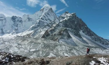
Trek to Gokyo Base Camp Cho La Pass and Gokyo walk, like most trek destinations in the Everest region, is relatively difficult. The majority of the routes are rugged and wind up and down, making the climb difficult for trekkers. The pathways leading to Everest Base Camp and Cho La Pass are rocky and filled with boulders. The journey follows the glacier, which is fairly slippery; thus, climbers must use a trekking pole and crampons.
For incidental expenses during the Everest Base Camp Cho La Pass Gokyo Trek, travel insurance is required. It reduces financial risks and protects passengers against certain losses. Travel insurance covers medical bills and emergency evacuations that may arise during a trip.
If the trekkers become ill, travel insurance pays for helicopter rescue and even transports them to the nearest hospital for prompt medical treatment. As a result, we strongly advise all of our trekkers to obtain travel insurance so that they don’t have to worry about the costs.
To enter Sagarmatha National Park, hikers must pay a national park entry fee. Foreign nationals must pay US$30 per person to enter the sanctuary, whereas citizens of SAARC countries pay only US$15.
Similarly, a permit from the Khumbu Pasang Lhamu Rural Municipality is necessary. Trekkers must pay US$20 for the first four weeks and US$25 for stays longer than four weeks.
There is no need for you to purchase hiking equipment because we provide the majority of the necessary necessities, including a sleeping bag, down jacket, and duffel bag. We also provide trekking poles for tourists to use as they ascend the sloppy glacier of Cho La Pass. The equipment must be returned to Nepal Eco Adventure once the hike is completed.
Aside from the items stated, if any other equipment is lacking from the list, trekkers will have to purchase it themselves. Trekkers can carry their own equipment, but it may be more expensive..
As a result, the best option is to buy them from Thamel’s local merchants. They give complete trekking equipment at the greatest price available anywhere. There are a few shops that hire out hiking equipment for a low cost.
At higher altitudes, accommodations are poor. On the Everest Base Camp Cho La Pass Gokyo Trek, there are numerous lodging alternatives. Nonetheless, teahouses are the most popular since they are convenient and accessible even in remote settlements. These are less expensive and include all of the basic amenities, such as a single bedroom with a pillow, blanket, and bed coverings. They must, however, share the restroom.. Yet given the price, there’s not much to bargain about.
If you were only trekking to the base camp, you might be able to make the hike without a porter. But, with the addition of the Cho La and Gokyo treks, you will need to hire a porter to assist you in carrying the bag. They’ll lighten your load and make your journey to Gokyo Lake a little easier and more comfortable.
Porters in the Everest region charge between $20 and $25 for 20 kg of weight. However, because your vacation package already includes it, there is no need to worry. However, you must guarantee that there is no additional load; otherwise, the porter will charge a greater fee.
On the Everest Base Camp Cho La Pass Gokyo Trek, there are numerous lodges and guesthouses that offer facilities at a low rate. Teahouses use solar panels to provide wi-fi to guests even at greater elevations. But, keep in mind that the cellphone network in the mountain is poor and frequently disconnects.
Cho La Pass, Everest Base Camp The Gokyo trip begins in Lukla, a lovely village in Khumbu at 2860 meters. Crossing the river before travelling through the untamed forest, vibrant valleys, and cities takes nearly two weeks of the walk to base camp..
Despite the long distance to the base camp, the trail allows you to thoroughly acclimate and appreciate the spectacular scenery. It follows the main EBC trail to base camp before changing to the Gokyo trail, which passes across Cho La Pass.
The trail even passes Ngozumpa Glacier on its way to Gokyo Valley, which is regarded as one of the most difficult walks in the world. The trail returns to Lukla via Gokyo and a picturesque flight from the town.
During the peak hiking seasons, Spring and Autumn, the trail to base camp is generally congested. Due to the harsh heat and temperature, winter and monsoon seasons attract less visitors. Gokyo is less visited by trekkers than Everest Base Camp because to the difficult topography and rough terrains.
EBC The Cho La Pass Gokyo Trek is mostly a teahouse trip, therefore there are guesthouses in practically every stop and village. Their facilities are simple yet adequate, with comfortable accommodations and delectable meals. Although these guesthouses supply blankets, it is always a good idea to bring a sleeping bag with you because the temperature is cold at such a high elevation.
More than 5,000 meters high above deep valleys and cliffs, the Cho La Pass and Everest Base Camp is the most impressive landmark in the Khumbu region. But, trekking here is not easier, with many challenges to brave, including its long and steep trails.
They also have to deal with unforeseeable weather in the Himalayas that changes instantly. To tackle these difficulties, hikers will need the right equipment that makes the journey more comfortable and better. They have to carefully select the items going in a backpack and ensure that it suits the preferred season.
Trekkers will have to determine what they need before the trek and plan accordingly. They must eliminate unwanted equipment as it only adds the load and makes the walk even more difficult. Not to forget that the weather impacts your need for trekking equipment, so buy the suitable essentials for the particular moment.